National weather forecasting centre india Significant Weather Features:
- A Low Pressure Area has formed over the Southeast Bay of Bengal and the adjoining South Andaman Sea due to a cyclonic circulation. The associated cyclonic circulation extends up to 5.8 km above mean sea level and is expected to intensify over the North Andaman Sea and its surroundings in the next 24 hours.
- Anticipated Weather Effects:
Widespread rainfall, thunderstorms, lightning, and gusty winds are expected over the Andaman & Nicobar Islands for the next four days. Isolated heavy to very heavy rainfall is likely between March 31st and April 1st, 2021.Fishermen are advised to avoid venturing into the Southeast Bay of Bengal and the adjoining South Andaman Sea on March 31st, and the Andaman Sea and areas of the Bay of Bengal on April 1st and 2nd,

Northeast India will experience:
- Fairly widespread to widespread rainfall with thunderstorms, hailstorms, thunder squalls, and lightning, primarily on March 31st and 1st April.
- Isolated heavy rainfall over Assam & Meghalaya and Nagaland, Manipur, Mizoram & Tripura on March 31st, with the potential for landslides and inundation in some areas.Maximum temperatures will decrease by 3-5°C over the plains of Northwest India in the next two days, alleviating heat wave conditions. However, another heat wave spell is expected to occur from April 3rd, 2021.
- Dust-raising strong surface winds (speed reaching 30-40 kmph) are expected over various regions, including Rajasthan, Haryana, Delhi, Uttar Pradesh, Punjab, Madhya Pradesh, Jharkhand, and Gangetic West Bengal between March 31st and April 1st.
Main Weather Observations:
- Rain and thundershowers were observed at several places, including Assam & Meghalaya, Andaman & Nicobar Islands, Sub-Himalayan West Bengal & Sikkim, Arunachal Pradesh, and isolated places in other regions.
- Significant rainfall of 1 cm or more was recorded in Haflong and Imphal (2 cm each), and Pasighat, Shillong, and Nancowry (1 cm each).
- Thunderstorms were observed at isolated places in Assam & Meghalaya and Manipur from March 31st to April 1st.
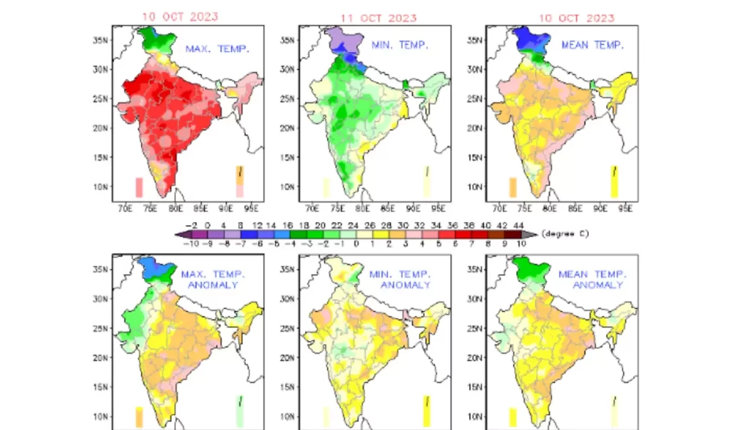
- Heat wave conditions were observed in some pockets of West Rajasthan, and isolated pockets in Himachal Pradesh, Madhya Pradesh, Jharkhand, Vidarbha, Odisha, Gangetic West Bengal, South West Uttar Pradesh, and East Rajasthan.
- Maximum temperature departures from normal were recorded in various regions, with some areas experiencing temperatures markedly above or below normal.
- The highest maximum temperature of 44.6°C was reported at Baripada, Odisha.
- Minimum temperature departures from normal were observed in different regions, with some areas experiencing temperatures markedly above or below normal.
- The lowest minimum temperature of 15.0°C was reported at Pantnagar, Uttarakhand, over the plains of the country.
Weather Forecast for the Next 5 Days
- A decrease in maximum temperatures by 3-5°C over the plains of Northwest India for the next three days, followed by a rise from April 3rd.
- A decrease in maximum temperatures by 3-5°C over Central India for the next three days.
- No significant change in maximum temperatures over Saurashtra & Kutch in the next 24 hours, with a subsequent rise of 2-3°C.
- A rise in maximum temperatures by 2-3°C over Andhra Pradesh and Telangana for the next 2-3 days.
- No significant change in maximum temperatures over the rest of the country for the next 5 days.
Weather Outlook for April 5th to 7th,
- Expect scattered to fairly widespread light rainfall/snowfall with thunderstorms and lightning over the Western Himalayan region on April 4th and 5th,
- Isolated rainfall with thunderstorms and lightning is likely over Northeast India, Kerala & Mahe, and Tamil Nadu, Puducherry & Karaikal.
- An active Western Disturbance is anticipated to affect the Western Himalayan region from the night of April 5th, leading to fairly widespread to widespread light to moderate rainfall/snowfall over the region during April 6th and 7th.
- Interaction with lower-level easterlies from the Bay of Bengal may cause isolated to scattered light rainfall with thunderstorm/lightning over Punjab, Haryana, North Rajasthan, and West Uttar Pradesh on April 6th and 7th, with maximum activity on April 7th.
- Dry weather is expected over the rest of the country.
Meteorological Analysis (Based on 0530 hours IST):
- A Low Pressure Area has formed over the Southeast Bay of Bengal and the adjoining South Andaman Sea, with an associated cyclonic circulation extending up to 5.8 km above mean sea level. It is expected to intensify over the North Andaman Sea and its neighborhood in the next 24 hours.
- The Low Pressure Area over the Southeast Arabian Sea and the adjoining Equatorial Indian Ocean has become less marked, but the associated cyclonic circulation persists.
- The cyclonic circulation over central Pakistan and its neighborhood extends up to 1.5 km above mean sea level.
- A trough in mid and upper tropospheric westerlies with its axis at 5.8 km above mean sea level persists roughly along Long. 92°E to the north of Lat. 22°N.
- The cyclonic circulation over west Assam and its neighborhood between 1.5 km and 2.1 km above mean sea level persists.
- A fresh feeble Western Disturbance is expected to affect the Western Himalayan Region from April 1st.
- Another fresh Western Disturbance is anticipated to affect the Western Himalayan Region from the night of April 3rd.
Weather Warning for the Next 5 Days:
31 (Day 1):
- Thunderstorm with lightning, hail, and gusty winds (speed reaching 40-50 kmph) is likely at isolated places over Assam & Meghalaya and Nagaland, Manipur, Mizoram & Tripura. Lightning and gusty winds (speed reaching 30-40 kmph) are expected at isolated places over Sub-Himalayan West Bengal & Sikkim, Odisha, Andaman & Nicobar Islands, Kerala & Mahe, Lakshadweep, and Arunachal Pradesh.
- Heavy to very heavy rainfall is very likely at isolated places over Andaman & Nicobar Islands, with heavy rainfall at isolated places over Assam & Meghalaya, Arunachal Pradesh, Nagaland, Manipur, Mizoram & Tripura, and Sub-Himalayan West Bengal & Sikkim.
- Heat Wave Conditions are very likely in isolated pockets over East Uttar Pradesh, Bihar, East Madhya Pradesh, Chhattisgarh, Rajasthan, Vidarbha, Jharkhand, Gangetic West Bengal, Odisha, and Telangana.
- Squally weather (wind speed reaching 40-50 kmph) is


